Wednesday, July 12, 2017


An image of  Tulare's Carnegie Library, circa 1911.   The photo is by  Howard Clinton Tibbitts.    This is a scan from the glass negative.           Built in 1905,  it served as a public library until 1963.     It was torn down in 1970.
A couple close-ups:


An old photo postcard of the Paige Store, circa 1910.
Paige was a small community about 4 miles SW of Tulare.    Paige is still listed on Google Maps, though there isn't much there anymore.     It was near the corner of Road 68 and Ave 216 (Paige Avenue).
The proprietor , W.T. Kneen, is listed in the 1910 Tulare County directory as a "postmaster and gen msde".   There are about 50 listings for the town of Paige in that directory.


Photograph by Doran Studio of Tulare.  Circa 1893.


 From a cyanotype photo postcard,  circa 1908.    This home was most likely in the Goshen area.


Photograph by the Visalia studio of E. M. Davidson. Circa 1892

Another baby photo by E. M. Davidson, circa 1892.


Photo postcard image of Visalia's 3-story Elks building, on the SW corner of Main and Locust Streets.   Image circa 1922.       Built in 1918, it was destroyed by fire in 1959.


Friday, June 9, 2017


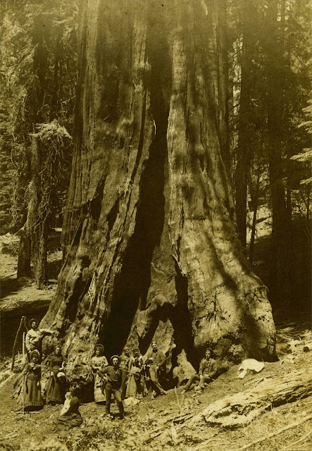
Genesis Tree, sequoia
Photograph by E. M. Davidson, of Visalia.  Circa 1893.
There is nothing on the photo identifying the people or the place.     But I'm fairly certain this is a photograph of the Genesis Tree, which is in the Mountain Home Demonstration State Forest, about 1/2 mile from Balch Park.
     This tree is somewhat of a recent discovery, in that up until the mid 1980's it was considered just one of many big trees in the Balch Park area (It didn't even have a name at that time).   It wasn't until about 1985 that measurements revealed that it was the biggest tree in the Mountain Home Grove (And the 7th largest tree in the world).   
I've read that there is graffiti carved into the tree dating from the late 1800's.  
   Apparently quite a few people stayed in this area during the summer.   e.g. In  Floyd L. Otter's book, The Men of Mammoth Forest he states:  "It has been estimated by people who frequented the area during these years(around 1887 to 1900) that 1000 to 2500 people could sometimes be found camping in the Mountain Home-Summer Home-Camp Lena area during the heat of the summer.";  The area described here is basically the  Mountain Home State Forest and Balch Park.
I've laid out most of the reasons why I think this is the Genesis Tree, on a page Here
Close up:
Genesis Tree, Mountain Home


Postcard photo of Traver's Southern Pacific Railroad depot, circa 1913.     According to an old article,   the depot was one of the first buildings in town.   It was moved from Traver in the mid-1930's,  and ended up a dairy barn.    It was actually the last building still there at old Traver, before being moved.     The present town of Traver was  built on the  site of the old town.


An old photo postcard, at its bottom it reads:   "Goddess of Liberty  July 4 - 09  Visalia Calif.".     It appears to be an image of a  horse-drawn float depicting a stylized airship, being piloted by the goddess.   The photo is by Weissenfluh of Visalia.      I believe the building the background is the Tipton Lindsay School, which was located on the  NW corner of  Oak Ave. and Locust Street.

(Added 2/2/19)  Another postcard photo of that float (see the previous image).   This one is also by Weissenfluh;  and dated July 4, 1909.     In the background is the Jacob Building, on the SW corner of Church and Main Streets.


Photograph of a girl, circa 1895.     No photographer is listed, but apparently their studio was in the Holt Block  building of Visalia.   This building was on the NW corner of Court and Main Streets.   The name "Bertha Rouden" is written on the back of the photo.


Photo postcard of Orosi's Methodist Episcopal Church, circa 1911.


Old photo postcard, circa 1915.     This appears to be a Christian tent meeting in Visalia, e.g. It looks like a dirt floor in the image.      During this period, many groups could have held such a meeting in Visalia.     e.g. The Church of God (Anderson, Indiana)  had a meeting in Visalia, in 1914.

Thursday, April 27, 2017

 Photo postcard image of Exeter's  Pine Street, circa 1911.


Photo postcard.    Post-marked: "Portersville Cal., Feb. 24, 1907". 
 There's no ID  for the children with the card.      I haven't been able to pin-down the exact location yet. There were several palm tree lanes like this in the Porterville/Lindsay area.      This could be the palm lane near the ranch of J. H. Williams of Porterville.

(Added 5/5/17)  From an old photo postcard, circa 1908.     I believe this is the same Palm Ave.  that's in the previous image.


A snapshot of sunbathers at the old Bartlett Park swimming hole,  Porterville.    Circa 1916.      Along the Tule River,  this area is now under  Lake Success.           (Update/Correction, 7/5/17):  Actually there was no Bartlett Park in 1916.    I just received the following information from  Laurie Schwaller, of the Tulare County Treasures:
" In 1923, the Porterville Chamber of Commerce sponsored a fundraising drive to acquire land for a park on the Tule River.  The necessary funds were raised very quickly.  The land was purchased (about 34 acres?) and then donated to the County, with the understanding that it would be developed and maintained as a County park by the County Forestry Board, headed by William Pitt Bartlett of Porterville.  Bartlett had served on the Forestry Board since its creation and had a great deal to do with the development of Mooney Grove Park and Cutler Park (as well as Murry Park in Porterville).  The new park was named Tule River County Park.  I have heard that the land on which it was situated had been used as a swimming hole for a number of years previously.
In February, 1929, the Board of Supervisors, in response to a petition signed by many organizations, businesses, and individuals in Porterville, renamed the park as W. P. Bartlett Memorial Park, to honor the seriously ill Mr. Bartlett.  Bartlett died July 5, 1929."


Another snapshot from the old Tule River swimming hole.


Photo postcard, circa 1910.     Looking east down Tulare Ave. ,  Tulare CA; near the intersection with J  Street.      This appears to be a George Besaw postcard.


An old photo postcard, of the 1906 flood in Visalia. (Visalia flooded several times that year.)
The image is of the old county courthouse, on the NW corner of Church Street and Center Ave.
The high curbing and corner stones are still present today.


Another postcard image from the 1906 Visalia flood.   This is an image of the old Odd Fellows hall on the NE corner of Church and Center.

Sunday, February 26, 2017


Photo postcard of the Townsend School, circa 1913.   Photo by Vogt.    This school was located in Elderwood,  on the east side of Millwood Drive;  a couple miles north of Woodlake.    It was later renamed the Elderwood School.
According to Marsha Ingrao's book about Woodlake:   The school was built in 1908 and would have only had two rooms at the time of this photograph.


Photo postcard of  Woodlake's  Brick Block building.   Circa 1914.   It was located at the NE corner of  Valencia and Naranjo Boulevards.     Apparently someone thought they sold good bananas there.


Postcard image of the Woodlake's Presbyterian Church under construction.   Circa 1913.


Photo postcard by Vogt.   Circa 1915.     So far,  I haven't been able to find out what exactly these gentlemen were "Stockholders" of.


Sprinville,  circa 1914.     I'm not sure what this building was.    I posted this image to a Springville facebook group.   The best clue I got from  FB  was that this structure was possibly used as an extension for the Mt. Whitney School in Springville, during the early 1920s.


Postcard image of Strathmore, circa 1913.    The two-story brick building at the left side of the image appears to be the Strathmore Block building.    This structure still stands and its appearance hasn't changed very much.    It's located on the SE corner of Bruce Drive and Orange Belt Drive.

Sunday, February 12, 2017


The studio ID printed on the back of this photo:  "Giant Forest Studio.   Lindley Eddy,  Photographer.   Ranger, Tulare Co., Cal.".        Ranger was the site of a post office, a ranger's station and Eddy's studio in Sequoia National Park.   The photo is circa 1915.
Close-up:


Photo postcard circa 1910.   "F. Donley"  probably refers to Frank Donley of Dinuba.     


Photograph of a Tulare creamery by Howard Clinton Tibbitts, circa 1912.    This is a scan from the glass negative.    The sign on the building indicates that this is part of the Dairymen's Co-operative Creamery Association  (DCCA).       The DCCA was created in 1909.   It  merged with Land O'Lakes, Inc., in 1998.
Close-up:


Another  Howard C. Tibbitts photo, circa 1912.   This is a scan from the glass negative.    Tibbitts  listed this image as  a "Creamery at Tulare".


Photo postcard of  Strathmore, circa 1913.