Thursday, December 8, 2016


Photo postcard by Lindley Eddy, circa 1912.     I believe the "Kaweah Colony Canyon",  refers to the 
to the area near the the Kaweah Post Office


The Orosi Library was established in March 1911 in Ryan's Cyclery.    It was officially established as a Tulare County Library Branch in July, 1913.     After WWI,  a  Carnegie library was built in Orosi  and that building still serves as the county library branch for that town.


Photo postcard by Beck,  circa 1911.    This section of Tulare's  J  Street  was also known as "Front St."

Image from an old postcard.     It's postmarked "Lindsay, CAL., Nov. 14, 1907".    The person who sent the card wrote on the back: "This is a picture of orange hauling at Lindsay Cal.".
Close up:


An old photo postcard image of the Palace Hotel in Visalia,  postmarked 4/18/1909. 
Built in 1876,  this building still stands on the NE corner of Main & Court Streets.   It's the oldest commercial building still in use in Visalia and probably the southern San Joaquin Valley.
Close up:
 A close-up showing some of the signage:   There's a couple of "Palace Bar" signs,   A poster that starts "National League Base Ball Results..." (I can't read the rest of the poster),    And there's a corner street sign for Court and Main Street.


The Tulare County Courthouse,  circa 1921.     This is a view looking south down Court Street near its intersection with Oak Ave.


Monday, November 7, 2016


Richgrove,  circa 1914
 An image of the town of Richgrove, circa 1914.    This is a scan from the original glass negative.
Annie R. Mitchell, in her book 'The Way it Was'  (1976),  states that the Reid Land and Development Company started this town in 1909.  The company built this store and the hotel (on the right side of the image) as well as put in streets and sidewalks.    In 1913,  a freeze killed most of the young citrus trees planted in the area; which was one reason  why the town never grew very much.       The photograph was taken by the Cheney Photo Advertising Company.
 Close up:
Richgrove Hotel, circa 1914
Close up of the Hotel Richgrove.   This building still stands, its on the south side of Chaney Drive about 200 feet east of  Richgrove Drive (Route J35).


A small photograph by Hammond's Studio of Porterville  (Photographer: Eschol M. Hammond).   Circa 1923.     It appears to be an image of some campers taking  time-out to pose for the camera.


Photograph by Doran Studio of Tulare, circa 1893.


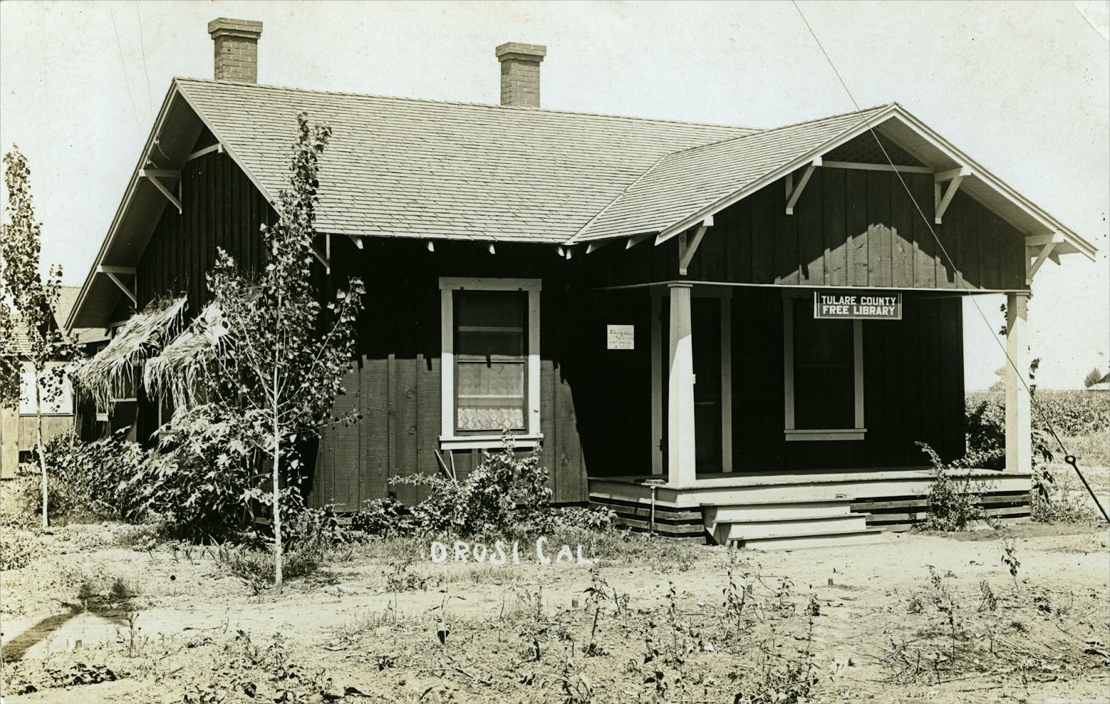
Postcard image of Orosi, circa 1910.
(Update 5/8/20) The Culter-Orosi Courier published a printed postcard using this same image.  They described it as "Looking east on El Monte from Road 127 about 1908."


Postcard image of Lindsay's First Church of the Nazarene, circa 1923.    
The church still stands, it's located on the corner Samoa St. and Gale Hill Ave.


Visalia's Southern Pacific Railroad depot, circa 1906.   Photo postcard by Ramsey.
According to local historian Terry Ommen:   This depot was built in 1893 and served as both the passenger and freight depot.    It was on the southeast corner of  Church St. and Oak Ave.     In 1915, the depot was moved one block to the east so that a new passenger depot could be built on that corner (Which is now the Depot Restaurant).    This old depot was destroyed by arson in 1982.


A postcard view of some groves and fields near Orosi,  circa 1909.


Postcard  of Lindsay's Presbyterian Church, circa 1912.


Photo postcard of Porterville's Main Street,  near the street's intersection with Garden Ave.   Circa 1909.    This is a view looking north.    The Morton Street School can be seen at the northern end of Main St.       The theater building, at the right-center of the image, also housed photographer A. R. Moore's Opera House Studio.      
Close-up:


Photo postcard image of Tulare, circa 1908.   This is a view from Kern Ave, looking down K  St.    The First National Bank is at the left edge of this image,  directly accross K Street from it is Linder's Hardware.   Both these buildings are  still standing.


Photo by A. R. Moore of  Porterville,  circa 1908.
Most likely this is the family of  William Samuel Lawson (aka  Sam Lawson)  of  Plano and Porterville.     His wife's name was Anna and his daughter is Florence.


Photograph circa 1914.     On the back of this photo someone has written what looks like: "Chet,   343 S. Mirage"  (or it could possibly be 243 S. Mirage).     The person who sold the photo to me stated that this is an image of Chet Tienken of Lindsay.    I'm guessing that "Chet" is Chester R. Tienken (1910-1993) of Lindsay.   He was the child of Albert C. Tienken and Alberta Mae Cox.   The "343"  matches the street number for his family's house in the 1920 U.S. Census.

Wednesday, September 7, 2016

A small snapshot taken at Mooney Grove, 1920.


 Postcard image of Ducor's water tower, circa 1910.


 Drying peaches, most likely in the Exeter area.  Circa 1912.    This is a  cyanotype  print (Thus the bluish color.).


Postcard image of the Ranger Post Office in Giant Forest (Sequoia National Park).   Circa 1910.


Photo postcard of the Terra Bella Hotel  in  Terra Bella.  Circa 1911.   This was one of the structures built by the Terra Bella Development Company (a real-estate company), to promote the town's growth.

(Added 11/5/16)  Another postcard view of the Hotel Terra Bella.  Circa 1911.


Postcard image of the Christian Church of  Porterville, circa 1910.
Close up:
The sign above the door states:  "Christian Church    G.D. King".
The 1909  Porterville City Directory lists the  Rev. Guilford D. King as the pastor of the Christian Church.
According to the Rev. King's  testimonial  for the Easy Method Music Co.,   he would have been 75 years old on (or before) 1915...   So I would guess that he's the elderly gentleman in this image. 

Sunday, August 28, 2016

Postcard image of Lindsay's Main Street.    The photographer was probably George Besaw,  circa 1909


 Photo postcard by Beck, circa 1911.      Taken near the corner of  Tulare Ave. and  K Street.


Postcard image of Orosi,  circa 1911.  
Close-up:


Another photo postcard of Orosi.   Circa 1910.   Note that the building at the near-right of this photograph also appears on the right side of the Orosi postcard  above.  i.e.  It looks like the same street, viewed in two different directions.


A  George Besaw postcard of Lindsay's  Southern Pacific Railroad depot, circa 1909.


Another image of Lindsay's railroad depot;  taken from a different angle (see above).    Circa 1910.


Postcard image of Exeter's  Methodist Church.   Circa 1909.

Porterville's Congregationalist Church.  Circa 1910.


Photo portrait of a young boy,  by E. M. Davidson of Visalia.   Circa 1892.


Postcard of Visalia's Main Street, looking east.    Photo by Ramsey, circa 1907.
The Holt Block building is at the left side foreground,  its small cupula tower was on the NW corner of  Court and Main Streets (where Starbucks is now).   The bank clock-tower further down the street was at the NW corner of Church and Main,  where the five story Bank of Italy building was later built.
Close-up:


Image from a photo postcard sent by Harriett  L. Villemin,  postmarked  9/3/1908.     Harriett identifies this as "our bungalow",  in Plano CA.     The 1910 U.S. Census lists Harriett as living in Plano with her husband Lewis and her son Lewis Jr..


Photo portrait by  A. R. Moore's  Opera House Studio in Porterville.  Circa 1910.


Postcard image of Porterville's Pioneer Hotel, on Main St.   Circa 1909.


Photo postcard of  Dinuba,  looking southerly down L Street (Near the corner of Tulare and L).  Circa 1911.     I believe the building,  on the left,  with the second floor balcony is the Commercial Hotel.    On  1/30/2016,  I posted a photo which appears to be taken from this hotel's balcony.
Close-up:


Saturday, July 2, 2016

Photo postcard of Exeter's Southern Pacific Railroad depot, circa 1909.    Postcard by George Besaw.   To the left of the depot is a Visalia Electric Railroad passenger car.
Close-up:
Visalia Electric used these types of passenger cars from 1908 to 1924.   Note the apparatus mounted on top of the car (called a pantograph),  it collected power through contact with an overhead electrical wire.
The Visalia Electric Railroad company existed until 1992,  but they stopped using electric freight locomotives in 1944.  i.e. After 1944 they used diesel locomotives, and the company was just "Electric" in name.

Old postcard of a Visalia Electric Railroad freight locomotive,  circa 1913.

Old photograph of workers on the Visalia Electric Railroad track.    The electric locomotives could travel from Visalia to Exeter, and then on to depots in Lemon Cove and Woodlake.   
Despite the company's name, it was an Exeter based subsidiary of the Southern Pacific Railroad.


The Visalia Electric Railroad bridge, crossing the Kaweah River near Lemon Cove.  Note the power lines over the middle of the track.  
 I posted another photo of this bridge on  5/12/2012.


Old photo postcard from Lemon Cove, circa 1908.
Written on the back of the card: "Lemon Cove Depot, Jeff Paregien, Click Paregien - 6yrs."    Most likely these names refer to Jefferson M. Paregien of Lemon Cove and his son Charles Clifton Paregien.    
This depot was built to service the Visalia Electric Railroad.     It was located just west of the intersection of Road 244 and Avenue 328.   The depot and the railroad tracks are no longer there.
A couple close-ups: