Tuesday, May 29, 2012


Here's five photos I bought online that were sold as a group.
Names are written on the back of each picture, but most of the names were apparently misspelled.
After doing a little research I came to the conclusion that the first 3 photos here are members of the Pogue family.   More specifically, they are children of James William Center Pogue (1839-1907).
      J.W.C. Pogue was an important Tulare County pioneer.  He was a successful citrus grower,  rancher and businessman.  He also served two terms as a Tulare County supervisor, and he created the town of  Lemon Cove, CA.   The historic Lemon Cove Woman's Clubhouse was originally the Pogue Hotel, and then later the Pogue residence, before the family deeded the house to the Women's club.
Because this is a family of some importance it made it somewhat easier to identify these Pogue family members.
The last two pictures here are apparently members of the Moffett family, although I'm not exactly sure yet which of the Moffetts they are.     On two occasions there appears to have been intermarriage between the Pogue and Moffett families, and Eva Pogue (photo just below) co-wrote a history of the  "Blair - Moffett"  families.


Sarah Eva Pogue.  Eva Pogue Kirkman.
At the bottom of this photo it says:  "Flaglor",  "Instantaneous Photographs", "S.E. cor. Market and Ninth Sts."', "San Francis."   (circa 1885-1890).      On the back is written:  "Eva Pogue".   I'm sure this is Sarah Eva Pogue (Later, Eva Pogue Kirkman). Born: Dry Creek, Tulare County (in 1870),  D.:  in 1946 (Exeter, CA).


Nancy Eugenia Pogue.  Genie Pogue Crookshanks.
 On the back of this picture someone has written: "Jene Pague".  I'm fairly certain that this is a photo of Nancy Eugenia Pogue  (later, Genie Pogue Crookshanks),  b. 1864, Venice Hills, Tulare County,  d. .1931, Exeter. CA .       The Photo is by: "Bell", "Santa Ana, Cal", (circa 1885-1890).
With both Genie and Eva Pogue it is possible to find other photographs of them on the internet, which helped considerably when trying to identifying who these are photos of.


Earl Pogue
Photo by:  "S. W. Watrous" (Stephen West Watrous), "Holt Block, Visalia.", (circa 1887).
"Earl Pague" is written on the back of this photo.  I'm pretty sure this is Jonathan Early Pogue (1867-1944), brother to Eva and Genie.  Apparently he just went by the name Earl. (e.g. In the 8/12/11 issue of The Foothills Sun-Gazette, Exeter CA, he is referred to as "Earl Pogue".)


James Moffett.   Pogue.
On the back of this picture someone has written "Jim Maffett", which I believe is actually suppose to be Moffett... it's in the same handwriting as the person who misspelled Pogue (writing instead "Pague") on two of the photos above.  Apparently they had a problem with confusing their a's and o's.
The photographer's seal on the back says:  "From S. W. Watrous' Photographic Rooms, Main Street, Visalia",  (circa 1885).


Joseph Moffett.  Pogue.
On the back of this picture is written:  Joe Moffett (or possibly Jol Moffett).
And the photographer's seal there reads:  "From S. W. Watrous' Photographic Rooms, Main Street, Visalia, Cal.",  (circa 1885).  

(Updated 9/27/12):  After doing a little research, my best guess as to the identity of the two Moffett gentlemen is that:  The first photo is of  James Blair Moffett,  Born: Mendocino County, 1861.  D: 1915 in Mexico.    The second photo is of Joseph Larkin Moffett, Born: Mendocino County, 1860. D: 1924 in Visalia.  
The two are brothers.   Their family moved to an area not far from the Pogue family in 1866. 
If I have the details right, their father was the half-brother of  Nancy Mayfield Moffett Blair (The grandmother of those members of the Pogue family pictured above.).


Thursday, May 24, 2012

Old photographs of Tulare County's schools:


Porterville.  The old Morton Street School.

 Porterville Grammar School.   Circa 1906.
Back then, the northern end of Main St.  was here at the Morton Street School.

(Added 5/24/14)  This is what the Morton Street School (see previous photo) looked like after 1907.   They didn't tear down the old school building;  they removed the bell tower, added east & west wings, and also added columns and a balcony.        
 Photo postcard by the Western Card Company,  George Besaw photographer.  Circa 1910.


Washington School in Visalia.  Around 1910.
 Post-marked 1910.

Image of the Washington Grammar School, Visalia.     Circa 1911.    Photo by Howard Clinton Tibbitts.     This is a scan from the glass negative.

Dinuba High School,  circa 1908.
 Dinuba High School,  circa 1908.

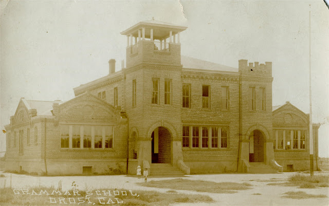
Orosi grammar school.  Circa 1912.
 Orosi Grammar School, circa 1912.

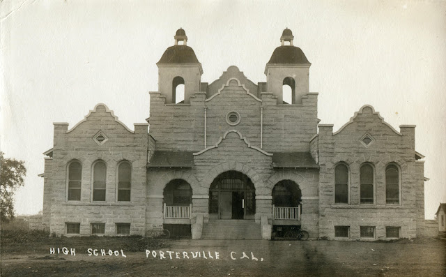
Porterville high school in 1909.
Porterville High School, circa 1909 (which stood on the present site of  Belleview Elementary School).
 This Mission Revival styled building was known as El Granito, because it was constructed of granite from a local quarry.

 (Added 3/20/15)  Another view of El Granito circa 1909.


(Added 2/15/14)  Visalia High School in 1921.  This is the present site of Redwood High School.


(Added 3/5/14)  Tulare High School.  Circa 1912.

(Added 5/25/14)  Woodlake School,  circa 1914.


 (Added 11/5/16)  An image of Webster Grammar School, Visalia. Circa 1919.
Wikipedia has this to say about the school (the listed source is Terry Ommen), "Webster Grammar School was located in the West Village on Northwest Third Avenue near Pearl Street.  It opened in 1917.  In 1950, the building was declared unsafe as a school and was later converted into a maintenance shop and storage building.  In 1961, fire damaged the structure beyond repair.  The Visalia Police Department Substation now sits on the site."


(Added 11/5/16)   Photo postcard, circa 1912.   This Exeter grammar school was at the present site of Lincoln Elementary School. 

 
 (Added 11/5/16)  Dinuba Grammar School, circa 1916.    Photo by James Henry Parfitt.
Parfitt's home base was Tigerton and Eagle River, Wisconsin.  His wife had family in the Dinuba area.


 (Added 11/5/16)    Photo postcard circa 1912.    In Sarah Troop's book about Lindsay, CA;   she refers to this as the Little Red Schoolhouse.

Photo from Lindsay, circa 1903.    This appears to be an earlier photograph of  Lindsay's Little Red Schoolhouse, with a different bell-tower (see the previous image).

 
(Added 11/5/16)  Photo postcard of Lindsay's  Washington Grammar School, circa 1920.


(Added 11/5/16)   Lindsay's High School, circa 1912.    According to Sarah Troop,  this high school was built in 1909 and was located on the NE corner of Harvard Ave. and East Hermosa St.      Note that the postcard's caption refers to this as Lincoln High School.  The name on the school itself  is  Lindsay High School   (see the next image).

 (Added 11/5/16)  Same Lindsay school as in the previous image, apparently from around the same time period.    But in this photo the name on the school is  Lincoln Grammar School.

(Added 1/21/18)  Another photo postcard image of Lincoln Grammar School, circa 1912.   Lindley Eddy is the photographer.


(Added 11/5/16)  Old photo postcard, circa 1915.   Most likely it's the grammar school at Strathmore, CA.


(Added 11/5/16)   Postcard image, circa 1909.    According to Derryl A. Dumermuth's book  A Town Called Tulare (2002),  this school was built around 1885 as a elementary school.   High school classes began there in 1890.   One of the unique features of this building was the four-faced clock above the belfry.

(Added 2/12/17) An image of the Tipton Lindsay School, circa 1912.   The school was located on the  NW corner of  Oak Ave. and Locust Street in Visalia, where the county library is now.     Photo by Howard Clinton Tibbitts.     This is a scan from the glass negative.      Built in 1890, this beautiful 3 story schoolhouse was unfortunately constructed poorly.   By 1916,  the building was considered too unsafe for school children.  It was torn-down in 1919.

(Added 2/4/18)  Photo postcard of the Tipton Lindsay school, in Visalia.  Circa 1909.    Photo by Ramsey.


(Added 2/12/17) Photo postcard circa 1906.    This Dinuba school was built in 1890.    It was torn-down after suffering damage from the 1906 San Francisco earthquake,


(Added 1/21/18) Photograph by the Visalia studio of S.W. Watrous, circa 1890.
 I believe this is the old Vandalia Schoolhouse in Porterville.
(Update 11/6/19) After recently looking at some more  images of old schools in Tulare Co.,  I now suspect that this is an image of the school at Traver, circa 1890.    I think that the  image I was previously comparing it to is actually an old photo of the Traver school, that has been mislabeled as the Vandalia school.


(Added 4/5/20)  Lemon Cove's school, circa 1910.    Lindley Eddy was the photographer.


(Added 4/5/20)  Yettem's school, circa 1912.      Early in the 1900s,  Yettem was a settlement of predominately Armenian immigrants.    Yettem is the Armenian word for Eden.

Wednesday, May 23, 2012

Here are some photo postcard views of California Hot Springs


California Hot Springs.  Tulare County.  In 1909.
"Johnie (and) Stella 1909", California Hot Springs.
This particular site was known as the Barrel Spring.


(Added 3/9/15)  A photo postcard image of the Barrel Spring, circa 1910.


(Added 3/9/15)  Photo postcard image taken at the Barrel Spring,  circa 1909.


(Added 6/9/17)  This is what the Barrel Spring looked like, several years later.   Postcard image circa 1913.


California Hot Springs.  Tulare County.  Hotel Del Venado.  Circa 1910
Hotel Del Venado, California Hot Springs.  Circa 1910. 

Close up:
Note the beds out on the second floor balcony.

//////////////////////////////////////////////////////////////////////////////////////////////////////////////////


California Hot Springs.  Tulare County.  Circa 1906.
Another photo postcard view of the Hotel Del Venado, from a different angle.  Circa 1906.


(Added 3/29/14)  A similar view of Cal Hot Springs as the photo above, but from slightly earlier.  Circa 1905.


California Hot Springs.  Tulare County.  In 1911.
(Update 7/24/12)  And yet another photo postcard view of this hotel.  Post-marked 1911.


(Added 3/5/14)  Old photo postcard.  Post-marked 1913.


(Added 8/29/16)  The dining room of the Hotel Del Venado, circa 1910.


///////////////////////////////////////////////////////////////////////////////////////////////////////////////////


California Hot Springs.  Tulare County.  Circa 1914
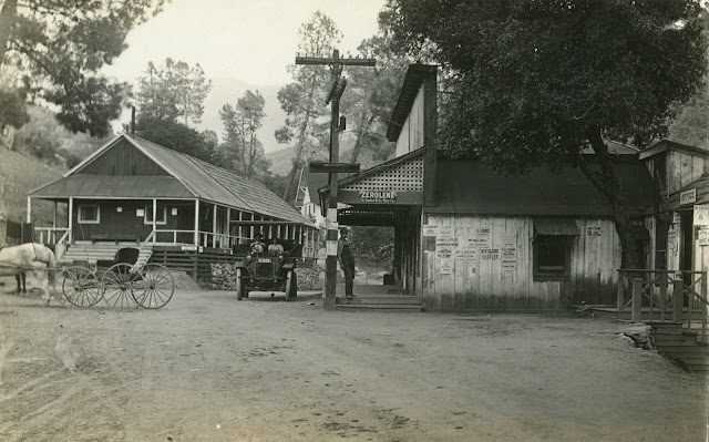
Another view of the hot springs.   Judging from the signs and campaign posters, this picture was probably taken around 1914.

Close-up:


/////////////////////////////////////////////////////////////////////////////////////////////////////////////////////

(Update 10/5/12)   Below are more photo postcards of California Hot Springs, each have the same studio ID stamped on the back:  "Robert A. Parker, Mountain Photographs.  Bear Creek Studio,  Huntington Lake, Calif.    1119 Franklin Ave. Fresno, Calif." (circa 1920)

 California Hot Springs.  Tulare County. Circa 1920.  Hotel Annex


California Hot Springs.  Tulare County.  View of hotel.  Circa 1920.
 A photograph of the Hotel Del Venado taken from a nearby hill.    This hotel was destroyed in a 1932 fire.


California Hot Springs.  Tulare County.  Circa 1920.  Hotel.


California Hot Springs.  Tulare County.  Circa 1920. Guests


California Hot Springs.  Tulare County.  Circa 1920. Town view.
 A picture of Cal Hot Springs taken from the balcony of the hotel.

(Added 4/8/14)   California Hot Springs with snow,  circa 1920.     This photo postcard is also by Robert A. Parker.   The building at the left side of the photo was the bathhouse,  to the right side  is a store which I believe also housed the post office.   These structures  were torn-down in the early 1920's, and were replaced by Mission Revival styled buildings.


   ///////////////////////////////////////////////////////////////////////////////////////////////////////////////////


California Hot Springs.  Tulare County.  In 1914.
 (1/9/13 Update).    On the back of this photo postcard is a printed location seal: "Views From California Hot Springs,  Tulare Co., Cal.".      There is also a little writing on the back but the only thing I can decipher from it is the date of 1914. 

Close-up:
California Hot Springs.  Tulare County. In 1914.  Tourist.


(Added 11/17/14)  Another photo postcard view of the hot springs.  This one is postmarked Sept. 17, 1908.
Close-up:


(Added 1/27/15)  On the back of this photo postcard is printed:  "Views From California Hot Springs,  Tulare Co., Cal.".  Circa 1910.     This woman is probably crossing Deer Creek,  which runs through Cal. Hot Springs.


 (Added 5/8/15)  Auto stage at Cal Hot Springs, circa 1914.
 Close-Up:


(Added 11/8/16)  Another view of one of Cal Hot Springs earlier auto-stages.   Circa 1914.   Compared to the previous photo, the steering wheel is on the opposite side....   or perhaps the image was simply reversed (?).


(Added 8/28/16)  Circa 1918,  Photo postcard of  the auto-stage at Cal Hot Springs.


(Added 11/8/16)  Cal Hot Springs'  auto-stage,  circa 1920.


(Added 5/18/15)  Old photo postcard, circa 1919.     This particular spot at the hot springs was known as  The Grotto.


 (Added 12/10/15)  On the back of this photo postcard is printed:  "Views From California Hot Springs,  Tulare Co., Cal.".   It's postmarked 1909.    I haven't seen another reference to an  "Elk & Deer Paddock" at Cal Hot Springs.   I have read that they kept pet deer at the Springs, during this period.

 (Added 8/29/16)  A postcard view of the Elk  & Deer Paddock, similar to the one above.


(Added 8/29/16)   Postcard postmarked 1/16/1914.    Printed on the back: "Views From California Hot Springs,  Tulare Co., Cal.".     This appears to be a different view of the paddock,  clearly showing a couple of  pet elk.     The Hotel Del Venado can be seen in the background.


(Added 12/10/15)  On the back of this postcard is printed:  "Views From California Hot Springs,  Tulare Co., Cal.".   Postmarked 1908.    For many years,  people could rent tents and cabins (as well as stay at the hotel) at Cal Hot Springs.


 (Added 12/10/15)  Printed near the bottom of this postcard "Capanero Falls", "Cal Hot Springs".   Capanero Falls is about a quarter mile from the Springs.   Circa 1919.
 Close-up:


(Added 8/29/16)   Postcard circa 1914.   Printed on the back:  "Views From California Hot Springs,  Tulare Co., Cal.".

  (Added 8/29/16)  Photo postcard circa 1919.   The Grotto spring appears to be at the near-right (behind the woman in the white dress).     The Barrel Spring  is in the background, left-center.


(Added 8/29/16)  Postcard image of three girls at Deer Creek,  Cal Hot Springs.  Circa 1907.


(Added 8/29/16)  Tourists on horses and mules at Cal Hot Springs, circa 1915.


  (Added 8/29/16)  Early postcard of the Cal Hot Springs area, circa 1904.    Best I can tell, this is some sort of makeshift sawmill.  e.g. I can make out a sizable steam engine, with a belt drive and a couple circular saw blades.    If I remember correctly,  much of the lumber for Hot Springs was cut   in nearby areas.


(Added 2/12/18)  Photo postcard from California Hot Springs, circa 1916.         At least seven of the men here appear to be U.S. Forest Rangers, e.g. From the badges they are wearing.
Cal Hot Springs was the summer headquarters for the Sequoia National Forest, during this period.

/////////////////////////////////////////////////////////////////////////////////////////////////////////////////// 

Below are a few images of the Arnold family and friends,  during the 1910s.


 An old photo postcard from California Hot Springs,  circa 1915.
The names of the people are listed on the back of the card, (from L to R): Pauline & Loise Arnold (on horseback),  Jim Arnold,  I'm fairly certain the next person is Lillie Arnold (Jim Arnold's wife), then Amelia Stoutenburger,   John Stoutenburger (on horseback) and Grant Moody.    The location is written on the back as the "Arnold Homestead".
In the 1910 U.S. Census, the Arnolds are listed in the Cal Hot Springs area.   Annie R. Mitchell's family is listed just after the Arnold family, in the 1910 census.
Pauline Arnold (Hamilton) passed away in Porterville, in 1989.   Her younger sister, Loise Arnold (Bluekle) passed away in Springville, in 2006.
  The name "Stoutenburger" is apparently a misspelling of Stoutenburgh.   From what I can tell from online genealogy, census and voting records: Amelia Stoutenburgh moved to Cal Hot Springs, with her son John, sometime after the death of her husband in 1913.
Close-up:


(Added 2/12/18)   From a photo postcard, circa 1912.   Written on the back:  "Pauline Arnold, Hot Springs Ca.  3 yrs old".    The Elk & Deer Paddock is just to the left.

  
(Added 2/12/18) Written on the back of this old  postcard: "Jim Arnold, Hot Springs, Ca. Homestead."


(Added 2/12/18)   Another photo postcard of the Arnold family & friends, circa 1915. The location written on the back is "Frog Meadow, Hot Springs, Ca.".      The names are listed on the back, from L to R:   Dale Mynatt (Lillie Arnold's brother),  then Dale's wife Gladys Mynatt,  Amelia Stoutenburg,  Lillie Arnold,  Grant Moody,  Wes Waldon,  Thelma Burtner and Rollie Arnold (Jim Arnold's brother).     "Wes Waldon" maybe Wesley F. Waldon, records seem to suggest that he later married Amelia Stoutenburgh.

(Added 2/12/18)  Another photo postcard from the Arnold family, circa 1915.

/////////////////////////////////////////////////////////////////////////////////////////////////////////////////// 


(Added 2/2/19)  Campers at Cal Hot Springs, circa 1917.